Geolocate

Oranjestad topographic map

Click on the map to display elevation.

About this map

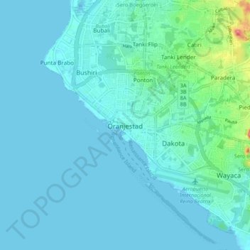
Name: Oranjestad topographic map, elevation, terrain.

Location: Oranjestad, Aruba, 000, Netherlands (12.48687 -70.07568 12.56687 -69.99568)

Average elevation: 12 m

Minimum elevation: -2 m

Maximum elevation: 152 m

Gear up for your next adventure:

💡Portable Camping Lamp - Rechargeable lamp for campsite lighting
🛶Kayak Dry Bag - Waterproof storage for kayaking adventures
Camping Tent - Weather-resistant tents suitable for 2 to 6 people
🩹Moleskin Blister Pads - Direct protection for painful foot pressure points
🔥Emergency Fire Starter - Reliable ignition source for all weather conditions

As an Amazon Associate, this site earns from qualifying purchases at no extra cost to you.