Geolocate

Töging topographic map

Click on the map to display elevation.

About this map

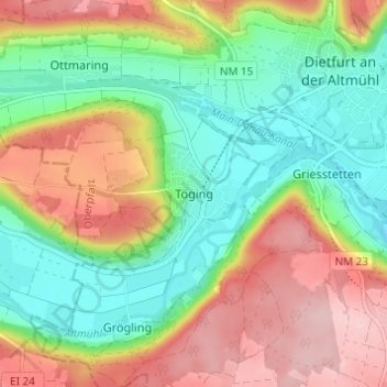
Name: Töging topographic map, elevation, terrain.

Location: Töging, Dietfurt an der Altmühl, Landkreis Neumarkt in der Oberpfalz, Bayern, 92345, Deutschland (49.00355 11.54047 49.04355 11.58047)

Average elevation: 431 m

Minimum elevation: 351 m

Maximum elevation: 536 m

Other topographic maps

Click on a map to view its topography, its elevation and its terrain.

Gear up for your next adventure:

🔋Lithium AA Batteries - Long-lasting power that performs in extreme cold
🔭Compact Binoculars - Lightweight optics for scouting trails and wildlife
Lightweight Backpacking Tent - Compact tent for efficient hiking trips
👟Trail Running Shoes - Agile footwear for fast-paced topographic exploration
🥾Lightweight Hiking Shoes - Comfortable shoes for day hikes

As an Amazon Associate, this site earns from qualifying purchases at no extra cost to you.