
Oberstdorf topographic map
Click on the map to display elevation.
About this map
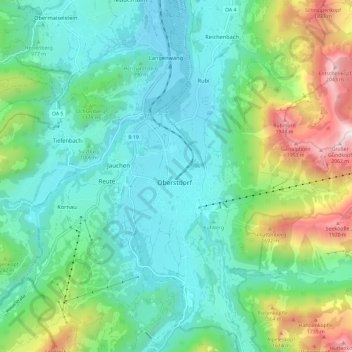
Name: Oberstdorf topographic map, elevation, terrain.
Location: Oberstdorf, Landkreis Oberallgäu, Bayern, 87561, Deutschland (47.37183 10.23810 47.45183 10.31810)
Average elevation: 1,098 m
Minimum elevation: 760 m
Maximum elevation: 2,099 m
Other topographic maps
Click on a map to view its topography, its elevation and its terrain.
Oytal
Deutschland > Bayern > Landkreis Oberallgäu > Oberstdorf > Oberstdorf
Am Oybach führt der Dr.-Hohenadl-Weg entlang. Eine Fahrstraße, die für den Kraftfahrzeugverkehr nur mit besonderer Erlaubnis des Marktes Oberstdorf freigegeben ist, führt von Oberstdorf ca. 5 km bis zur Hälfte des Tales zum Oytalhaus auf 1010 m Höhe. Vom Oytalhaus sind die Untere Gutenalp (1048 m) und…
Average elevation: 1,448 m
Oberer Gaisalpsee
Deutschland > Bayern > Landkreis Oberallgäu > Oberstdorf > Oberstdorf
Der Obere Gaisalpsee ist ein 0,8 Hektar großer Hochgebirgssee auf 1769 Meter Höhe in den Allgäuer Alpen und zählt damit zum Naturschutzgebiet Allgäuer Hochalpen. Er hat keinen oberirdischen Abfluss und liegt in einer Geländestufe südlich oberhalb des Unteren Gaisalpsees (1508 m), die von Rubihorn,…
Average elevation: 1,694 m