Geolocate

Toulouse topographic map

Click on the map to display elevation.

Toulouse

The first half of the 14th century was a prosperous period, despite the dismemberment in 1317 of the very large bishopric of Toulouse (which lost two-thirds of its area and part of its income, not compensated by its elevation to the rank of archbishopric), and the episode of the Shepherds' Crusade which brought a pogrom against Toulouse's Jewish population in 1320.

About this map
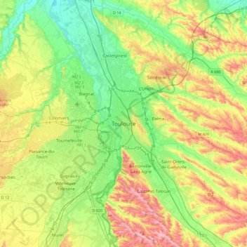
Name: Toulouse topographic map, elevation, terrain.

Location: Toulouse, Haute-Garonne, Occitania, Metropolitan France, 31080, France (43.44446 1.28425 43.76446 1.60425)

Average elevation: 173 m

Minimum elevation: 104 m

Maximum elevation: 288 m

Gear up for your next adventure:

🥾Hiking Boots - Sturdy boots providing ankle support and traction on rugged trails
🕯️Camping Lantern - Illuminates your entire campsite with high-efficiency LEDs
🧢Sun Protection Cap - Breathable cap to protect from sun exposure
🥾Mountain Hiking Shoes - Shoes with superior grip for mountainous terrain
🧣Merino Neck Gaiter - Protects against wind, sun, and cold at high altitudes

As an Amazon Associate, this site earns from qualifying purchases at no extra cost to you.