
Make a donation
Gear up for your next adventure:
As an Amazon Associate, this site earns from qualifying purchases at no extra cost to you.
Monticello topographic map
Click on the map to display elevation.
Make a donation
Gear up for your next adventure:
As an Amazon Associate, this site earns from qualifying purchases at no extra cost to you.
Monticello
According to the U.S. Census Bureau, the city has a total area of 8.94 square miles (23.15 km2), all land. The city's latitude is 45.305 degrees North and its longitude is 93.793 degrees West. Its elevation is 922 feet. Monticello is in the Central time zone.
Make a donation
Gear up for your next adventure:
As an Amazon Associate, this site earns from qualifying purchases at no extra cost to you.
About this map
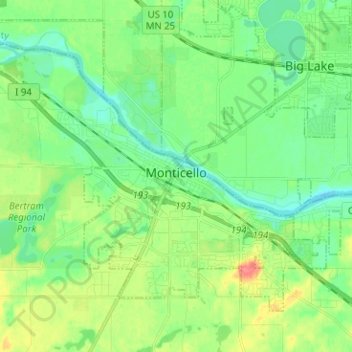
Name: Monticello topographic map, elevation, terrain.
Location: Monticello, Wright County, Minnesota, 55362, United States (45.27053 -93.86106 45.33840 -93.73503)
Average elevation: 289 m
Minimum elevation: 270 m
Maximum elevation: 327 m
Make a donation
Gear up for your next adventure:
As an Amazon Associate, this site earns from qualifying purchases at no extra cost to you.