Geolocate

Coates Mills topographic map

Click on the map to display elevation.

About this map

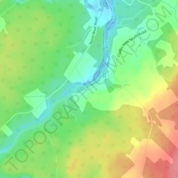
Name: Coates Mills topographic map, elevation, terrain.

Location: Coates Mills, Saint Mary Parish, Kent County, New Brunswick, E4S 2E6, Canada (46.36090 -64.88397 46.38090 -64.86397)

Average elevation: 35 m

Minimum elevation: -4 m

Maximum elevation: 81 m

Kent County trails, hiking, mountain biking, running and outdoor activities

Other topographic maps

Click on a map to view its topography, its elevation and its terrain.

Saint-Paul Parish

Canada > New Brunswick > Kent County

Average elevation: 70 m

Harcourt Parish

Canada > New Brunswick > Kent County

Average elevation: 77 m

Dundas Parish

Canada > New Brunswick > Kent County

Average elevation: 31 m

McLean Brook

Canada > New Brunswick > Kent County

Average elevation: 53 m

Richibucto

Canada > New Brunswick > Kent County > Richibucto

Average elevation: 4 m

Gear up for your next adventure:

🔋Lithium AA Batteries - Long-lasting power that performs in extreme cold
🛰️Satellite Messenger - Emergency communication for areas with no cell service
🥾Trekking Poles - Adjustable trekking poles to reduce knee stress and improve stability
🧥Insulated Jacket - Keep warm in cold outdoor conditions
🧊Insulated Water Bottle - Keeps drinks cold in summer and prevents freezing in winter

As an Amazon Associate, this site earns from qualifying purchases at no extra cost to you.