
Make a donation
Gear up for your next adventure:
As an Amazon Associate, this site earns from qualifying purchases at no extra cost to you.
Barsinghausen topographic map
Click on the map to display elevation.
Make a donation
Gear up for your next adventure:
As an Amazon Associate, this site earns from qualifying purchases at no extra cost to you.
Barsinghausen
Barsinghausen liegt am Höhenzug Deister im Übergangsgebiet zwischen den deutschen Mittelgebirgen und dem norddeutschen Tiefland. Die Stadt gehört administrativ zur Region Hannover und befindet sich im Calenberger Land, bei dem es sich um eine historische Landschaft südwestlich von Hannover handelt. Der Deister ist ein Naherholungsgebiet, das an das Weserbergland grenzt, und ist in seinen Ausläufern vom Stadtzentrum nur ca. 200 m entfernt. Der Ort liegt innerhalb der Calenberger Lössbörde mit fruchtbaren Ackerböden.
Make a donation
Gear up for your next adventure:
As an Amazon Associate, this site earns from qualifying purchases at no extra cost to you.
About this map
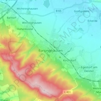
Name: Barsinghausen topographic map, elevation, terrain.
Average elevation: 148 m
Minimum elevation: 53 m
Maximum elevation: 380 m
Make a donation
Gear up for your next adventure:
As an Amazon Associate, this site earns from qualifying purchases at no extra cost to you.