
Thank you for supporting this site ❤️
Make a donation
Make a donation
Gear up for your next adventure:
As an Amazon Associate, this site earns from qualifying purchases at no extra cost to you.
Tabernáculo topographic map
Click on the map to display elevation.
Thank you for supporting this site ❤️
Make a donation
Make a donation
Gear up for your next adventure:
As an Amazon Associate, this site earns from qualifying purchases at no extra cost to you.
About this map
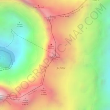
Name: Tabernáculo topographic map, elevation, terrain.
Location: Tabernáculo, La Candelaria, Penipe, Chimborazo, Ecuador (-1.67467 -78.40920 -1.67457 -78.40910)
Average elevation: 4,720 m
Minimum elevation: 4,168 m
Maximum elevation: 5,248 m
Thank you for supporting this site ❤️
Make a donation
Make a donation
Gear up for your next adventure:
As an Amazon Associate, this site earns from qualifying purchases at no extra cost to you.