
Make a donation
Gear up for your next adventure:
As an Amazon Associate, this site earns from qualifying purchases at no extra cost to you.
Les Ragias topographic map
Click on the map to display elevation.
Make a donation
Gear up for your next adventure:
As an Amazon Associate, this site earns from qualifying purchases at no extra cost to you.
About this map
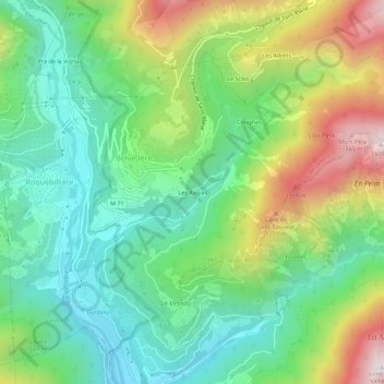
Name: Les Ragias topographic map, elevation, terrain.
Average elevation: 844 m
Minimum elevation: 494 m
Maximum elevation: 1,512 m
Make a donation
Gear up for your next adventure:
As an Amazon Associate, this site earns from qualifying purchases at no extra cost to you.
Other topographic maps
Click on a map to view its topography, its elevation and its terrain.
La Gordolasque
France > Provence-Alpes-Côte d'Azur > Alpes-Maritimes > Belvédère
D'une longueur de 18,7 km, elle prend source à 2 675 m d'altitude dans le vallon de la Fous, sur la commune de Belvédère. Elle a aussi pour source secondaire le lac Long (2 566 m), sur la terrasse du Gelas juste en dessous de la Cime du Gelas (3 143 m).
Average elevation: 1,841 m
Gias du Lac Autier
France > Provence-Alpes-Côte d'Azur > Alpes-Maritimes > Belvédère
Average elevation: 2,352 m
Le Granier
France > Provence-Alpes-Côte d'Azur > Alpes-Maritimes > Belvédère > En Giboï
Average elevation: 1,776 m
Make a donation
Gear up for your next adventure:
As an Amazon Associate, this site earns from qualifying purchases at no extra cost to you.
Lac Autier
France > Provence-Alpes-Côte d'Azur > Alpes-Maritimes > Belvédère
Le lac Autier se situe à 2 275 m d'altitude, et est profond de plus de 8 mètres pour une superficie de 2,2 hectares. Il est surplombé par le Mont Basto (2 794 m) et du Grand Capelet (2 935 m). Ce lac de type glaciaire n'est pas rehaussé d'un barrage, en aval l'eau est captée en plusieurs endroits pour les…
Average elevation: 2,399 m
La Gordolasque
France > Provence-Alpes-Côte d'Azur > Alpes-Maritimes > Belvédère
D'une longueur de 18,7 km, elle prend source à 2 675 m d'altitude dans le vallon de la Fous, sur la commune de Belvédère. Elle a aussi pour source secondaire le lac Long (2 566 m), sur la terrasse du Gelas juste en dessous de la Cime du Gelas (3 143 m).
Average elevation: 1,841 m