
Make a donation
Gear up for your next adventure:
As an Amazon Associate, this site earns from qualifying purchases at no extra cost to you.
Westford topographic map
Click on the map to display elevation.
Make a donation
Gear up for your next adventure:
As an Amazon Associate, this site earns from qualifying purchases at no extra cost to you.
About this map
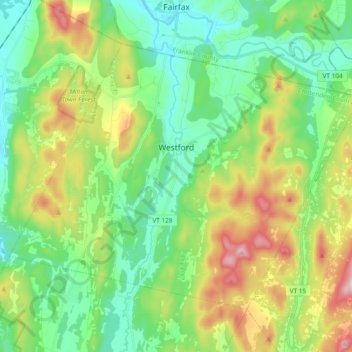
Name: Westford topographic map, elevation, terrain.
Location: Westford, Chittenden County, Vermont, 05494, United States (44.55031 -73.09792 44.65128 -72.90996)
Average elevation: 228 m
Minimum elevation: 98 m
Maximum elevation: 504 m
Make a donation
Gear up for your next adventure:
As an Amazon Associate, this site earns from qualifying purchases at no extra cost to you.
Other topographic maps
Click on a map to view its topography, its elevation and its terrain.
Make a donation
Gear up for your next adventure:
As an Amazon Associate, this site earns from qualifying purchases at no extra cost to you.
Starr Farm Beach
United States > Vermont > Chittenden County > South Burlington
Average elevation: 34 m
Make a donation
Gear up for your next adventure:
As an Amazon Associate, this site earns from qualifying purchases at no extra cost to you.
South Burlington
United States > Vermont > Chittenden County > South Burlington > South Burlington
Average elevation: 86 m
Make a donation
Gear up for your next adventure:
As an Amazon Associate, this site earns from qualifying purchases at no extra cost to you.
Fays Corner
United States > Vermont > Chittenden County > Richmond > Fays Corner
Average elevation: 231 m