Geolocate

Chicoasén topographic map

Click on the map to display elevation.

About this map

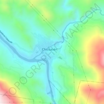
Name: Chicoasén topographic map, elevation, terrain.

Location: Chicoasén, Chiapas, Mexico (16.94637 -93.12450 16.98637 -93.08450)

Average elevation: 428 m

Minimum elevation: 187 m

Maximum elevation: 991 m

Gear up for your next adventure:

🔦LED Headlamp - Hands-free lighting for early morning starts or late finishes
🥾Hiking Shoes - Durable and comfortable shoes for trail hiking
🥾Trail Hiking Socks - Comfortable socks to prevent blisters and fatigue
🥾Lightweight Hiking Shoes - Comfortable shoes for day hikes
🥾Mountain Hiking Boots - High-traction boots for rocky terrain

As an Amazon Associate, this site earns from qualifying purchases at no extra cost to you.