Geolocate

Maasim topographic map

Click on the map to display elevation.

About this map

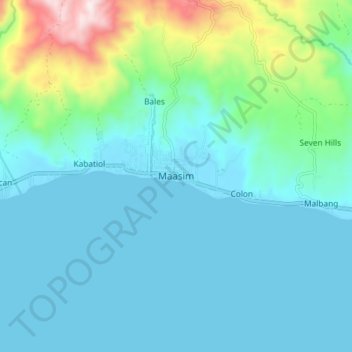
Name: Maasim topographic map, elevation, terrain.

Location: Maasim, Sarangani, Soccsksargen, Philippines (5.82101 124.95670 5.90101 125.03670)

Average elevation: 125 m

Minimum elevation: 0 m

Maximum elevation: 726 m

Other topographic maps

Click on a map to view its topography, its elevation and its terrain.

Mainit River

Philippines > Sarangani

Average elevation: 279 m

Sarangani Bay

Philippines > Sarangani

Average elevation: 103 m

Malungon

Philippines > Sarangani

Average elevation: 464 m

Glan River

Philippines > Sarangani

Average elevation: 384 m

Maasim

Philippines > Sarangani

Average elevation: 206 m

Buayan River

Philippines > Sarangani > Malungon

Average elevation: 149 m

Gumasa Beach

Philippines > Sarangani > Glan

Average elevation: 60 m

Malungon

Philippines > Sarangani

Average elevation: 460 m

Malungon

Philippines > Sarangani

Average elevation: 464 m

Gear up for your next adventure:

🧥Packable Rain Jacket - Breathable waterproof layer for unpredictable weather
🛏️Camping Sleeping Mat - Comfortable mats for sleeping outdoors
🧥Softshell Hiking Jacket - The perfect balance of wind protection and breathability
🧊Insulated Water Bottle - Keeps drinks cold in summer and prevents freezing in winter
🔦LED Headlamp - Hands-free lighting for early morning starts or late finishes

As an Amazon Associate, this site earns from qualifying purchases at no extra cost to you.