
Thank you for supporting this site ❤️
Make a donation
Make a donation
Gear up for your next adventure:
As an Amazon Associate, this site earns from qualifying purchases at no extra cost to you.
Changabang topographic map
Click on the map to display elevation.
Thank you for supporting this site ❤️
Make a donation
Make a donation
Gear up for your next adventure:
As an Amazon Associate, this site earns from qualifying purchases at no extra cost to you.
About this map
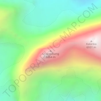
Name: Changabang topographic map, elevation, terrain.
Location: Changabang, Joshimath Tehsil, Chamoli, Uttarakhand, Inde (30.50039 79.92662 30.50049 79.92672)
Average elevation: 5,804 m
Minimum elevation: 5,115 m
Maximum elevation: 6,884 m
Thank you for supporting this site ❤️
Make a donation
Make a donation
Gear up for your next adventure:
As an Amazon Associate, this site earns from qualifying purchases at no extra cost to you.