
Thank you for supporting this site ❤️
Make a donation
Make a donation
Gear up for your next adventure:
As an Amazon Associate, this site earns from qualifying purchases at no extra cost to you.
Làng Sá topographic map
Click on the map to display elevation.
Thank you for supporting this site ❤️
Make a donation
Make a donation
Gear up for your next adventure:
As an Amazon Associate, this site earns from qualifying purchases at no extra cost to you.
About this map
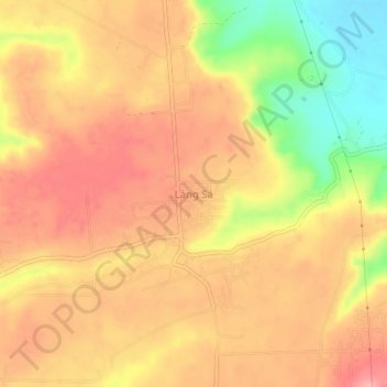
Name: Làng Sá topographic map, elevation, terrain.
Location: Làng Sá, Kon Tum City, Kon Tum province, 600000, Vietnam (14.29794 107.90855 14.33794 107.94855)
Average elevation: 592 m
Minimum elevation: 519 m
Maximum elevation: 633 m
Thank you for supporting this site ❤️
Make a donation
Make a donation
Gear up for your next adventure:
As an Amazon Associate, this site earns from qualifying purchases at no extra cost to you.