Geolocate

Padang topographic map

Click on the map to display elevation.

About this map

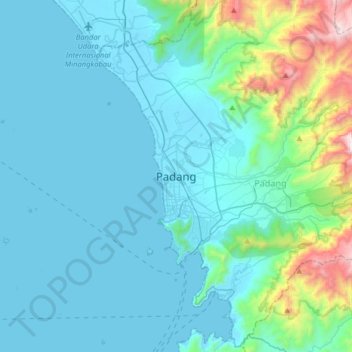
Name: Padang topographic map, elevation, terrain.

Location: Padang, West Sumatra, 25136, Indonesia (-1.08476 100.20326 -0.76476 100.52326)

Average elevation: 213 m

Minimum elevation: -1 m

Maximum elevation: 1,593 m

Gear up for your next adventure:

🥾Mountain Hiking Shoes - Shoes with superior grip for mountainous terrain
🛶Waterproof Dry Bags - Keep electronics and clothes dry during river crossings
🥾Durable Hiking Shoes - Long-lasting shoes for frequent hiking
🦟Insect Repellent - Keep mosquitoes and black flies away in wooded areas
🦶Anti-Blister Balm - Prevents friction and hotspots during long ascents

As an Amazon Associate, this site earns from qualifying purchases at no extra cost to you.