
Thank you for supporting this site ❤️
Make a donation
Make a donation
Gear up for your next adventure:
As an Amazon Associate, this site earns from qualifying purchases at no extra cost to you.
Boutouab topographic map
Click on the map to display elevation.
Thank you for supporting this site ❤️
Make a donation
Make a donation
Gear up for your next adventure:
As an Amazon Associate, this site earns from qualifying purchases at no extra cost to you.
About this map
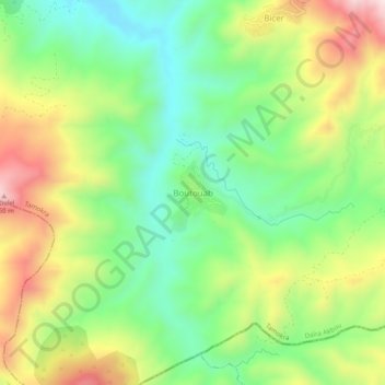
Name: Boutouab topographic map, elevation, terrain.
Location: Boutouab, Tamokra, Daïra Akbou, Béjaïa, 06520, Algérie (36.35411 4.60407 36.39411 4.64407)
Average elevation: 460 m
Minimum elevation: 250 m
Maximum elevation: 774 m
Thank you for supporting this site ❤️
Make a donation
Make a donation
Gear up for your next adventure:
As an Amazon Associate, this site earns from qualifying purchases at no extra cost to you.