Geolocate

Orono topographic map

Click on the map to display elevation.

About this map

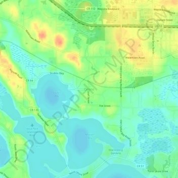
Name: Orono topographic map, elevation, terrain.

Location: Orono, Hennepin County, Minnesota, 55356, United States (44.95135 -93.62440 44.99135 -93.58440)

Average elevation: 295 m

Minimum elevation: 279 m

Maximum elevation: 324 m

Gear up for your next adventure:

🥤Collapsible Travel Cup - Saves space and weight in your mess kit
🦟Insect Repellent - Keep mosquitoes and black flies away in wooded areas
🥾All-Terrain Hiking Boots - Versatile boots for varied hiking conditions
🧦Outdoor Socks - Durable socks designed for hiking and outdoor sports
🛶Kayak Accessories - Essential gear for safe and fun kayaking adventures

As an Amazon Associate, this site earns from qualifying purchases at no extra cost to you.