Geolocate

Garampani topographic map

Click on the map to display elevation.

About this map

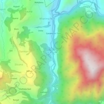
Name: Garampani topographic map, elevation, terrain.

Location: Garampani, Kosya Kutauli, Nainital, Uttarakhand, 262402, India (29.46181 79.45785 29.50181 79.49785)

Average elevation: 1,291 m

Minimum elevation: 882 m

Maximum elevation: 1,945 m

Gear up for your next adventure:

🧢Sun Protection Cap - Breathable cap to protect from sun exposure
🌡️Emergency Mylar Blankets - Compact thermal protection for unexpected nights outdoors
Lightweight Camping Tent - Portable shelter optimized for Canadian backcountry camping
🧣Merino Neck Gaiter - Protects against wind, sun, and cold at high altitudes
💧Reusable Water Bottle - Durable water bottles for hydration on trails

As an Amazon Associate, this site earns from qualifying purchases at no extra cost to you.