Geolocate

Juncal topographic map

Click on the map to display elevation.

About this map

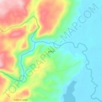
Name: Juncal topographic map, elevation, terrain.

Location: Juncal, Simití, Bolívar, Colombia (8.00623 -73.97996 8.04623 -73.93996)

Average elevation: 143 m

Minimum elevation: 40 m

Maximum elevation: 336 m

Other topographic maps

Click on a map to view its topography, its elevation and its terrain.

Río Boque

Colombia > Bolívar > Simití

Average elevation: 55 m

Gear up for your next adventure:

🏃Hydration Running Vest - Carry water and maps close to your body for speed
🥾Mountain Hiking Shoes - Shoes with superior grip for mountainous terrain
🧢Outdoor Visor - Breathable visor for sunny hikes
🛶Kayak Dry Bag - Waterproof storage for kayaking adventures
🔦LED Headlamp - Hands-free lighting for early morning starts or late finishes

As an Amazon Associate, this site earns from qualifying purchases at no extra cost to you.