Geolocate

Gawi topographic map

Click on the map to display elevation.

About this map

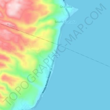
Name: Gawi topographic map, elevation, terrain.

Location: Gawi, Oslob, Cebu, Central Visayas, Philippines (9.56447 123.44990 9.60447 123.48990)

Average elevation: 86 m

Minimum elevation: 0 m

Maximum elevation: 346 m

Other topographic maps

Click on a map to view its topography, its elevation and its terrain.

Sumilon Island

Philippines > Cebu > Oslob

Average elevation: 0 m

Gear up for your next adventure:

🛏️Camping Sleeping Mat - Comfortable mats for sleeping outdoors
🧰Survival Kit - Essential gear for emergencies in the wilderness
🦶Hiking Shoe Insoles - Added support for high arches and long days on feet
🧢Beanie Hat - Keep your head warm in cold weather
🥾Mountaineering Boots - Supportive boots for climbing and high-altitude hiking

As an Amazon Associate, this site earns from qualifying purchases at no extra cost to you.