
Thank you for supporting this site ❤️
Make a donation
Make a donation
Gear up for your next adventure:
As an Amazon Associate, this site earns from qualifying purchases at no extra cost to you.
Rani topographic map
Click on the map to display elevation.
Thank you for supporting this site ❤️
Make a donation
Make a donation
Gear up for your next adventure:
As an Amazon Associate, this site earns from qualifying purchases at no extra cost to you.
Rani
Rani is located at 25°22′N 73°18′E / 25.37°N 73.3°E / 25.37; 73.3.[3] It has an average elevation of 273 metres (895 feet).
Thank you for supporting this site ❤️
Make a donation
Make a donation
Gear up for your next adventure:
As an Amazon Associate, this site earns from qualifying purchases at no extra cost to you.
About this map
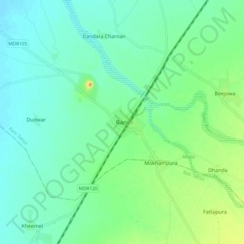
Name: Rani topographic map, elevation, terrain.
Location: Rani, Rani Tehsil, Pali, Rajasthan, 306115, India (25.30782 73.26823 25.38782 73.34823)
Average elevation: 279 m
Minimum elevation: 264 m
Maximum elevation: 319 m
Thank you for supporting this site ❤️
Make a donation
Make a donation
Gear up for your next adventure:
As an Amazon Associate, this site earns from qualifying purchases at no extra cost to you.