Geolocate

Harich topographic map

Click on the map to display elevation.

About this map

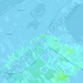
Name: Harich topographic map, elevation, terrain.

Location: Harich, De Fryske Marren, Frisia, Netherlands (52.86645 5.50110 52.93045 5.59527)

Average elevation: 0 m

Minimum elevation: -5 m

Maximum elevation: 7 m

Other topographic maps

Click on a map to view its topography, its elevation and its terrain.

Oost-Vlieland

Netherlands > Frisia

Average elevation: 2 m

Kooiplaats

Netherlands > Frisia > Buren

Average elevation: 1 m

Loënga

Netherlands > Frisia > Loënga

Average elevation: 0 m

Vierhuizen

Netherlands > Frisia > Allingawier

Average elevation: -2 m

Leeuwarden

Netherlands > Frisia > Leeuwarden

Average elevation: 0 m

Gear up for your next adventure:

🧥Ultralight Puffy Jacket - Maximum warmth that packs down to the size of an orange
🔦LED Headtorch - Bright and durable light for night activities
🚑Survival Whistle - Signal for help across long distances in mountains
Tent Footprint - Protect tent floor and increase durability
🥾Trail Hiking Shoes - Durable shoes designed for rugged trails

As an Amazon Associate, this site earns from qualifying purchases at no extra cost to you.