
Thank you for supporting this site ❤️
Make a donation
Make a donation
Gear up for your next adventure:
As an Amazon Associate, this site earns from qualifying purchases at no extra cost to you.
Bonchamp topographic map
Click on the map to display elevation.
Thank you for supporting this site ❤️
Make a donation
Make a donation
Gear up for your next adventure:
As an Amazon Associate, this site earns from qualifying purchases at no extra cost to you.
About this map
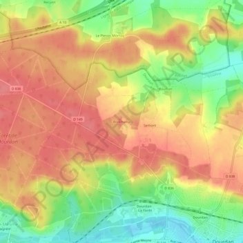
Name: Bonchamp topographic map, elevation, terrain.
Average elevation: 140 m
Minimum elevation: 95 m
Maximum elevation: 170 m
Thank you for supporting this site ❤️
Make a donation
Make a donation
Gear up for your next adventure:
As an Amazon Associate, this site earns from qualifying purchases at no extra cost to you.
Other topographic maps
Click on a map to view its topography, its elevation and its terrain.
Château de Dourdan
France > Île-de-France > Essonne > Dourdan
Le château se situe au creux de la vallée de l'Orge à moins de deux cents mètres au nord du lit de la rivière et à environ cent mètres d'altitude sur un terrain argileux.
Average elevation: 123 m