
Make a donation
Gear up for your next adventure:
As an Amazon Associate, this site earns from qualifying purchases at no extra cost to you.
Pendley topographic map
Click on the map to display elevation.
Make a donation
Gear up for your next adventure:
As an Amazon Associate, this site earns from qualifying purchases at no extra cost to you.
About this map
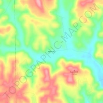
Name: Pendley topographic map, elevation, terrain.
Location: Pendley, Walker County, Alabama, United States (33.71317 -87.53195 33.75317 -87.49195)
Average elevation: 161 m
Minimum elevation: 97 m
Maximum elevation: 231 m
Make a donation
Gear up for your next adventure:
As an Amazon Associate, this site earns from qualifying purchases at no extra cost to you.
Other topographic maps
Click on a map to view its topography, its elevation and its terrain.
Make a donation
Gear up for your next adventure:
As an Amazon Associate, this site earns from qualifying purchases at no extra cost to you.
Tanyard Creek
United States > Alabama > Walker County > Jasper > Frisco Quarters
Average elevation: 110 m
Make a donation
Gear up for your next adventure:
As an Amazon Associate, this site earns from qualifying purchases at no extra cost to you.