Geolocate

Wilberforce topographic map

Click on the map to display elevation.

About this map

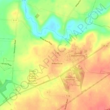
Name: Wilberforce topographic map, elevation, terrain.

Location: Wilberforce, Xenia Township, Greene County, Ohio, 45384, United States (39.69792 -83.90408 39.73461 -83.85689)

Average elevation: 297 m

Minimum elevation: 263 m

Maximum elevation: 320 m

Other topographic maps

Click on a map to view its topography, its elevation and its terrain.

Washington Mills

United States > Ohio > Greene County

Average elevation: 263 m

Wrightview

United States > Ohio > Greene County > Fairborn

Average elevation: 269 m

Gear up for your next adventure:

🧢Sun Hat - Wide-brim hat for sun protection
🥾Approach Shoes - Shoes designed for climbing approaches and rugged trails
🧶550 Survival Paracord - Versatile utility cord for emergency repairs and rigging
🥾Hiking Boots - Sturdy boots providing ankle support and traction on rugged trails
🥾Trekking Poles - Adjustable trekking poles to reduce knee stress and improve stability

As an Amazon Associate, this site earns from qualifying purchases at no extra cost to you.