
Make a donation
Gear up for your next adventure:
As an Amazon Associate, this site earns from qualifying purchases at no extra cost to you.
Lesachtal topographic map
Click on the map to display elevation.
Make a donation
Gear up for your next adventure:
As an Amazon Associate, this site earns from qualifying purchases at no extra cost to you.
About this map
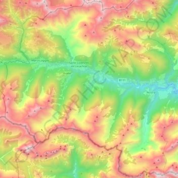
Name: Lesachtal topographic map, elevation, terrain.
Location: Lesachtal, Bezirk Hermagor, Carinzia, Austria (46.60461 12.68374 46.75668 12.90753)
Average elevation: 1,697 m
Minimum elevation: 812 m
Maximum elevation: 2,744 m
Make a donation
Gear up for your next adventure:
As an Amazon Associate, this site earns from qualifying purchases at no extra cost to you.
Other topographic maps
Click on a map to view its topography, its elevation and its terrain.
Obergail
Austria > Carinzia > Bezirk Hermagor > Lesachtal > Sankt Lorenzen im Lesachtal
Average elevation: 1,257 m
Make a donation
Gear up for your next adventure:
As an Amazon Associate, this site earns from qualifying purchases at no extra cost to you.
Passo di Pramollo
Austria > Carinzia > Bezirk Hermagor > Hermagor-Pressegger See > Sonnenalpe Naßfeld
Average elevation: 1,572 m
Make a donation
Gear up for your next adventure:
As an Amazon Associate, this site earns from qualifying purchases at no extra cost to you.
Creta di Aip
Austria > Carinzia > Bezirk Hermagor > Hermagor-Pressegger See
Average elevation: 1,794 m
Make a donation
Gear up for your next adventure:
As an Amazon Associate, this site earns from qualifying purchases at no extra cost to you.