Geolocate

Main topographic map

Click on the map to display elevation.

About this map

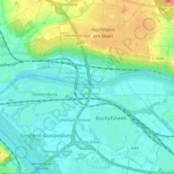
Name: Main topographic map, elevation, terrain.

Location: Main, Bischofsheim, Kreis Groß-Gerau, Hesse, Germany (49.99371 8.29135 50.00355 8.37062)

Average elevation: 99 m

Minimum elevation: 81 m

Maximum elevation: 149 m

Gear up for your next adventure:

🥘Camping Cookware Set - Compact nesting pots and pans for trail cooking
🏕️Camping Hammock - Integrated protection for sleeping between trees
🥾Mountain Hiking Shoes - Shoes with superior grip for mountainous terrain
Lightweight Camping Tent - Portable shelter optimized for Canadian backcountry camping
🎒Backpack Rain Cover - External shield to keep your entire pack dry

As an Amazon Associate, this site earns from qualifying purchases at no extra cost to you.