Geolocate

Glorit topographic map

Click on the map to display elevation.

About this map

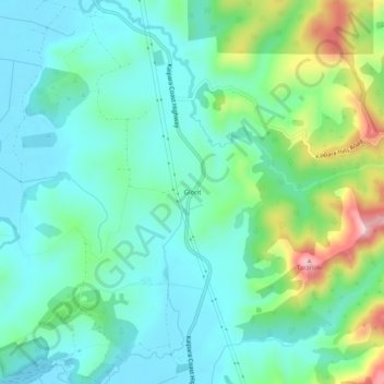
Name: Glorit topographic map, elevation, terrain.

Location: Glorit, Rodney, Auckland, New Zealand (-36.49443 174.42834 -36.45443 174.46834)

Average elevation: 66 m

Minimum elevation: 0 m

Maximum elevation: 267 m

Other topographic maps

Click on a map to view its topography, its elevation and its terrain.

Helensville

New Zealand > Auckland > Rodney

Average elevation: 21 m

Dome Forest

New Zealand > Auckland > Rodney

Average elevation: 168 m

Cowan Bay

New Zealand > Auckland > Rodney > Snells Beach

Average elevation: 22 m

Lake Rototoa

New Zealand > Auckland > Rodney

Average elevation: 102 m

Taupaki Estate

New Zealand > Auckland > Rodney > Kumeū

Average elevation: 37 m

Omaha Beach

New Zealand > Auckland > Rodney > Omaha

Average elevation: 3 m

Gear up for your next adventure:

🩹Compact First Aid Kit - Pre-packed essentials for common trail injuries
🩹Moleskin Blister Pads - Direct protection for painful foot pressure points
🛌Insulated Sleeping Pad - Critical thermal barrier between you and the cold ground
🔦LED Headtorch - Bright and durable light for night activities
🥾Light Hiking Boots - Lightweight and comfortable boots for day hikes

As an Amazon Associate, this site earns from qualifying purchases at no extra cost to you.