Geolocate

Saint-Roch-de-l'Achigan topographic map

Click on the map to display elevation.

About this map

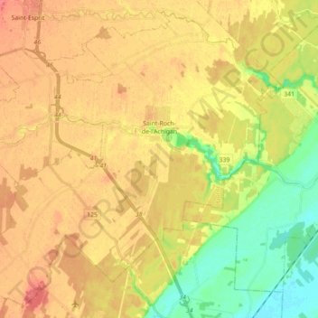
Name: Saint-Roch-de-l'Achigan topographic map, elevation, terrain.

Location: Saint-Roch-de-l'Achigan, Montcalm, Lanaudière, Quebec, J0K 3H0, Canada (45.78649 -73.70043 45.90082 -73.52447)

Average elevation: 46 m

Minimum elevation: 15 m

Maximum elevation: 70 m

Montcalm trails, hiking, mountain biking, running and outdoor activities

Other topographic maps

Click on a map to view its topography, its elevation and its terrain.

Saint-Calixte-Nord

Canada > Quebec > Montcalm > Saint-Calixte

Average elevation: 335 m

Gear up for your next adventure:

🧢Beanie Hat - Keep your head warm in cold weather
🕯️Camping Lantern - Illuminates your entire campsite with high-efficiency LEDs
🧦Outdoor Socks - Durable socks designed for hiking and outdoor sports
🛏️Sleeping Bag - Warm and compact sleeping bags for outdoor camping
🥾Trekking Poles - Adjustable trekking poles to reduce knee stress and improve stability

As an Amazon Associate, this site earns from qualifying purchases at no extra cost to you.