Geolocate

Labpur topographic map

Click on the map to display elevation.

About this map

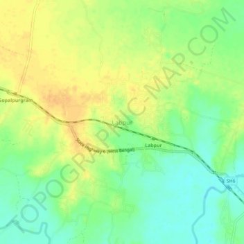
Name: Labpur topographic map, elevation, terrain.

Location: Labpur, Birbhum, West Bengal, 731303, India (23.79530 87.78008 23.83530 87.82008)

Average elevation: 37 m

Minimum elevation: 21 m

Maximum elevation: 51 m

Gear up for your next adventure:

🧢Beanie Hat - Keep your head warm in cold weather
🧥Thermal Fleece Jacket - Versatile insulation for changing mountain temperatures
🧥Thermal Layer - Insulating layer for cold outdoor conditions
🔨Vehicle Emergency Tool - Safety tool for remote road trips to trailheads
🥾Waterproof Hiking Shoes - Durable shoes for wet and rugged trails

As an Amazon Associate, this site earns from qualifying purchases at no extra cost to you.