
Make a donation
Gear up for your next adventure:
As an Amazon Associate, this site earns from qualifying purchases at no extra cost to you.
East Quincy topographic map
Click on the map to display elevation.
Make a donation
Gear up for your next adventure:
As an Amazon Associate, this site earns from qualifying purchases at no extra cost to you.
East Quincy
East-Quincy has a Mediterranean climate (Köppen Csb) though its inland location and altitude makes it more continental and wetter than usual for this type, with very heavy snowfalls sometimes occurring in winter – the record being 133 inches (337.8 cm) in the very wet January 1916.[5][6] Although summer days are hot and only 1.4 days per winter fail to top 32 °F (0 °C), nights can be very cold and frosts occur on 179 days per year and have been recorded even in July.
Make a donation
Gear up for your next adventure:
As an Amazon Associate, this site earns from qualifying purchases at no extra cost to you.
About this map
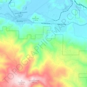
Name: East Quincy topographic map, elevation, terrain.
Location: East Quincy, Plumas County, California, United States (39.87772 -120.95454 39.95551 -120.86824)
Average elevation: 1,389 m
Minimum elevation: 1,035 m
Maximum elevation: 2,132 m
Make a donation
Gear up for your next adventure:
As an Amazon Associate, this site earns from qualifying purchases at no extra cost to you.
Other topographic maps
Click on a map to view its topography, its elevation and its terrain.