Geolocate

Reparo topographic map

Click on the map to display elevation.

About this map

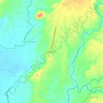
Name: Reparo topographic map, elevation, terrain.

Location: Reparo, Nasugbu, Batangas, Calabarzon, 4231, Philippines (14.05529 120.67075 14.09529 120.71075)

Average elevation: 38 m

Minimum elevation: 12 m

Maximum elevation: 92 m

Other topographic maps

Click on a map to view its topography, its elevation and its terrain.

Palico River

Philippines > Batangas > Nasugbu > Reparo

Average elevation: 44 m

Pico de Loro Beach

Philippines > Batangas > Nasugbu

Average elevation: 43 m

Fortune Island

Philippines > Batangas > Nasugbu

Average elevation: 1 m

Batulao

Philippines > Batangas > Nasugbu

Average elevation: 531 m

Talamitam

Philippines > Batangas > Nasugbu > Kayrilaw

Average elevation: 328 m

Fortune Island

Philippines > Batangas > Nasugbu

Average elevation: 1 m

Gear up for your next adventure:

🦟Insect Repellent - Keep mosquitoes and black flies away in wooded areas
🥾Lightweight Hiking Boots - Boots for comfort and mobility on long hikes
💧Collapsible Water Bottle - Space-saving water bottle for outdoor activities
🥾Approach Boots - Comfortable boots for hiking and climbing approaches
🥾Waterproof Hiking Boots - Essential footwear for rugged terrain and wet Canadian trails

As an Amazon Associate, this site earns from qualifying purchases at no extra cost to you.