
Make a donation
Gear up for your next adventure:
As an Amazon Associate, this site earns from qualifying purchases at no extra cost to you.
Higuera de Zaragoza topographic map
Click on the map to display elevation.
Make a donation
Gear up for your next adventure:
As an Amazon Associate, this site earns from qualifying purchases at no extra cost to you.
About this map
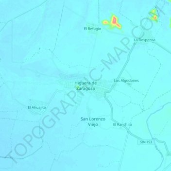
Name: Higuera de Zaragoza topographic map, elevation, terrain.
Location: Higuera de Zaragoza, Ahome, Sinaloa, México (25.92924 -109.34389 26.00924 -109.26389)
Average elevation: 8 m
Minimum elevation: 3 m
Maximum elevation: 101 m
Make a donation
Gear up for your next adventure:
As an Amazon Associate, this site earns from qualifying purchases at no extra cost to you.
Other topographic maps
Click on a map to view its topography, its elevation and its terrain.
Los Mochis
Los Mochis está ubicado en el noroeste del estado de Sinaloa. Sus coordenadas son 25°47′00″ latitud norte y 108°00′00″ longitud oeste. Se encuentra a una altitud de 10 m s. n. m. (metros sobre el nivel del mar). Tiene una superficie urbana de 61.242km² (kilómetros cuadrados).
Average elevation: 14 m