
Make a donation
Gear up for your next adventure:
As an Amazon Associate, this site earns from qualifying purchases at no extra cost to you.
Peutie topographic map
Click on the map to display elevation.
Make a donation
Gear up for your next adventure:
As an Amazon Associate, this site earns from qualifying purchases at no extra cost to you.
About this map
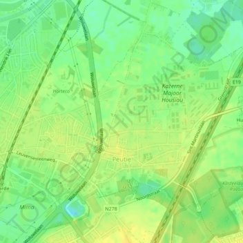
Name: Peutie topographic map, elevation, terrain.
Location: Peutie, Vilvoorde, Halle-Vilvoorde, Vlaams-Brabant, België (50.92117 4.44876 50.94136 4.48184)
Average elevation: 15 m
Minimum elevation: 3 m
Maximum elevation: 23 m
Make a donation
Gear up for your next adventure:
As an Amazon Associate, this site earns from qualifying purchases at no extra cost to you.
Other topographic maps
Click on a map to view its topography, its elevation and its terrain.
Drie Fonteinen
België > Vlaams-Brabant > Halle-Vilvoorde > Vilvoorde
Ter hoogte van de vroegere sluis van Drie Fonteinen werd rond 1975 een deel van het parkdomein verkaveld tot de wijk Lenterik, genoemd naar Sint-Lenterik en de gelijknamige kapel in het Domein Drie Fonteinen.
Average elevation: 26 m