
Phong Điền District topographic map
Interactive map
Click on the map to display elevation.
About this map
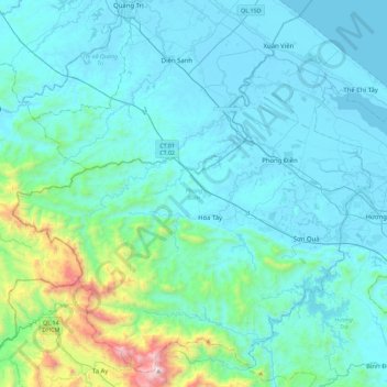
Name: Phong Điền District topographic map, elevation, terrain.
Location: Phong Điền District, Thừa Thiên Huế Province, Vietnam (16.34507 107.05490 16.74285 107.50440)
Average elevation: 207 m
Minimum elevation: -2 m
Maximum elevation: 1,739 m
Other topographic maps
Click on a map to view its topography, its elevation and its terrain.
Hue City
Vietnam > Thừa Thiên Huế Province
Hue City, Thừa Thiên Huế Province, Vietnam
Average elevation: 24 m
Hue
Vietnam > Thừa Thiên Huế Province > Hue City > Hue
Hue, Hue City, Thừa Thiên Huế Province, 54000, Vietnam
Average elevation: 31 m