
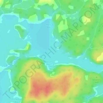
Wahwashkesh Lake topographic map
Interactive map
Click on the map to display elevation.
About this map
Name: Wahwashkesh Lake topographic map, elevation, terrain.
Average elevation: 237 m
Minimum elevation: 220 m
Maximum elevation: 266 m
Other topographic maps
Click on a map to view its topography, its elevation and its terrain.
Whitestone
Canada > Ontario > Parry Sound District > Whitestone
Whitestone, Parry Sound District, Central Ontario, Ontario, P0A 1G0, Canada
Average elevation: 249 m
Wahwashkesh
Canada > Ontario > Parry Sound District > Whitestone
Wahwashkesh, Whitestone, Parry Sound District, Central Ontario, Ontario, Canada
Average elevation: 230 m
Whitestone Lake
Canada > Ontario > Parry Sound District > Whitestone > Dunchurch
Whitestone Lake, Dunchurch, Whitestone, Parry Sound District, Central Ontario, Ontario, Canada
Average elevation: 269 m
Bolger Lake
Canada > Ontario > Parry Sound District > Whitestone
Bolger Lake, Whitestone, Parry Sound District, Central Ontario, Ontario, Canada
Average elevation: 237 m
Lorimer Lake
Canada > Ontario > Parry Sound District > Whitestone
Lorimer Lake, Whitestone, Parry Sound District, Central Ontario, Ontario, Canada
Average elevation: 256 m
Shanty Bay
Canada > Ontario > Parry Sound District > Whitestone
Shanty Bay, Whitestone, Parry Sound District, Central Ontario, Ontario, Canada
Average elevation: 232 m