
Make a donation
Gear up for your next adventure:
As an Amazon Associate, this site earns from qualifying purchases at no extra cost to you.
Rothmühle topographic map
Click on the map to display elevation.
Make a donation
Gear up for your next adventure:
As an Amazon Associate, this site earns from qualifying purchases at no extra cost to you.
About this map
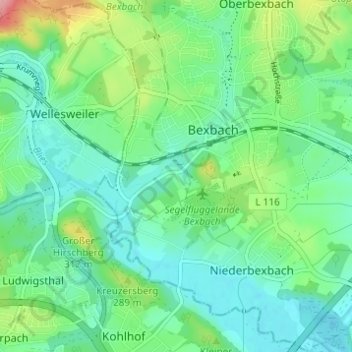
Name: Rothmühle topographic map, elevation, terrain.
Average elevation: 260 m
Minimum elevation: 225 m
Maximum elevation: 357 m
Make a donation
Gear up for your next adventure:
As an Amazon Associate, this site earns from qualifying purchases at no extra cost to you.
Other topographic maps
Click on a map to view its topography, its elevation and its terrain.
Frankenholz
Deutschland > Saarland > Saarpfalz-Kreis > Bexbach
Frankenholz ist ein Stadtteil von Bexbach im Saarland. Der Ort liegt am Südhang des Höcherberges auf etwa 300–450 Meter Meereshöhe. Die Fläche des Ortes beträgt 202 ha.
Average elevation: 380 m
Höchen
Deutschland > Saarland > Saarpfalz-Kreis > Bexbach
Durch die Bergehalde Schacht III als eine von weitem sichtbare Landmarke ist Höchen auch aus großer Ferne gut zu erkennen. Diese stellt die höchstgelegene Steinkohlenbergehalde Deutschlands dar mit einer Gipfelhöhe von 494,3 m ü. NHN.
Average elevation: 403 m
Oberbexbach
Deutschland > Saarland > Saarpfalz-Kreis > Bexbach
Außerhalb des Ortes auf der Südflanke des Höcherbergs im Wald Richtung Frankenholz betreibt die Ortsgruppe Oberbexbach des Pfälzerwald-Vereins seit 1971 auf 360 m Höhe die Steinberghütte. Von hier hat man eine sehr gute Aussicht auf die umliegenden Ortschaften.
Average elevation: 312 m