
Make a donation
Gear up for your next adventure:
As an Amazon Associate, this site earns from qualifying purchases at no extra cost to you.
Parc National de Chréa topographic map
Click on the map to display elevation.
Make a donation
Gear up for your next adventure:
As an Amazon Associate, this site earns from qualifying purchases at no extra cost to you.
About this map
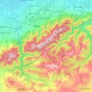
Name: Parc National de Chréa topographic map, elevation, terrain.
Location: Parc National de Chréa, Daïra Ouled Yaïch, Blida, 26140, Algérie (36.32461 2.64278 36.48728 3.01537)
Average elevation: 626 m
Minimum elevation: 32 m
Maximum elevation: 1,615 m
Make a donation
Gear up for your next adventure:
As an Amazon Associate, this site earns from qualifying purchases at no extra cost to you.
Other topographic maps
Click on a map to view its topography, its elevation and its terrain.
Chréa
Algérie > Blida > Daïra Ouled Yaïch
Le point plus haut du village est situé à 1 535 mètres d'altitude, au niveau de l'antenne de chrea
Average elevation: 872 m
Make a donation
Gear up for your next adventure:
As an Amazon Associate, this site earns from qualifying purchases at no extra cost to you.