Geolocate

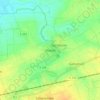
Elze topographic map

Click on the map to display elevation.

About this map

Name: Elze topographic map, elevation, terrain.

Location: Elze, Landkreis Hildesheim, Lower Saxony, 31008, Germany (52.06617 9.62811 52.16920 9.76282)

Average elevation: 104 m

Minimum elevation: 68 m

Maximum elevation: 362 m

Other topographic maps

Click on a map to view its topography, its elevation and its terrain.

Söhre

Germany > Lower Saxony > Landkreis Hildesheim

Average elevation: 139 m

Barienrode

Germany > Lower Saxony > Landkreis Hildesheim

Average elevation: 111 m

Mehle

Germany > Lower Saxony > Landkreis Hildesheim > Elze

Average elevation: 109 m

Gear up for your next adventure:

🥾Mountain Hiking Boots - High-traction boots for rocky terrain
💡Solar Camping Lamp - Eco-friendly lighting for campsites
🔭Compact Binoculars - Lightweight optics for scouting trails and wildlife
🧼Travel Hand Sanitizer - Keep hands clean when water is scarce
⛺Lightweight Backpacking Tent - Compact tent for efficient hiking trips

As an Amazon Associate, this site earns from qualifying purchases at no extra cost to you.