
Make a donation
Gear up for your next adventure:
As an Amazon Associate, this site earns from qualifying purchases at no extra cost to you.
Adams Township topographic map
Click on the map to display elevation.
Make a donation
Gear up for your next adventure:
As an Amazon Associate, this site earns from qualifying purchases at no extra cost to you.
Adams Township
Adams Township is located in the southeast corner of Cambria County at 40.392581, -78.542633, approximately 12 miles (19 km) east of Johnstown. According to the United States Census Bureau, the township has a total area of 46.2 square miles (119.7 km2), of which 46.1 square miles (119.4 km2) is land and 0.12 square miles (0.3 km2), or 0.26%, is water. The elevation rises to more 2,860 feet (870 m) above sea level in the southeastern part of the township, on Pot Ridge near the crest of the Allegheny Front.
Make a donation
Gear up for your next adventure:
As an Amazon Associate, this site earns from qualifying purchases at no extra cost to you.
About this map
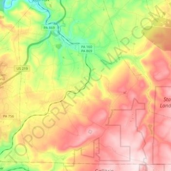
Name: Adams Township topographic map, elevation, terrain.
Location: Adams Township, Cambria County, Pennsylvania, United States (40.24266 -78.81362 40.36200 -78.64400)
Average elevation: 662 m
Minimum elevation: 431 m
Maximum elevation: 876 m
Make a donation
Gear up for your next adventure:
As an Amazon Associate, this site earns from qualifying purchases at no extra cost to you.
Other topographic maps
Click on a map to view its topography, its elevation and its terrain.
Spangler Reservoir
United States > Pennsylvania > Cambria County > Barr Township
Average elevation: 586 m
Twin Rocks
United States > Pennsylvania > Cambria County > Blacklick Township
Average elevation: 562 m
Parkhill
United States > Pennsylvania > Cambria County > East Taylor Township
Average elevation: 489 m
Mineral Point
United States > Pennsylvania > Cambria County > East Taylor Township
Average elevation: 527 m
Make a donation
Gear up for your next adventure:
As an Amazon Associate, this site earns from qualifying purchases at no extra cost to you.
Make a donation
Gear up for your next adventure:
As an Amazon Associate, this site earns from qualifying purchases at no extra cost to you.
Beaverdale
United States > Pennsylvania > Cambria County > Summerhill Township
Average elevation: 664 m
Make a donation
Gear up for your next adventure:
As an Amazon Associate, this site earns from qualifying purchases at no extra cost to you.
Gallitzin Tunnelhill Park
United States > Pennsylvania > Cambria County > Gallitzin
Average elevation: 682 m
Make a donation
Gear up for your next adventure:
As an Amazon Associate, this site earns from qualifying purchases at no extra cost to you.