
Make a donation
Gear up for your next adventure:
As an Amazon Associate, this site earns from qualifying purchases at no extra cost to you.
Forbach topographic map
Click on the map to display elevation.
Make a donation
Gear up for your next adventure:
As an Amazon Associate, this site earns from qualifying purchases at no extra cost to you.
Forbach
Der Kernort Forbach liegt im mittleren Murgtal an der Murg. Der Bahnhof hat die Höhenmarke 303 m ü. NN. Die Ortsteile Kirschbaumwasen (434 m ü. NN) und Raumünzach (392 m ü. NN) liegen etwas flussaufwärts, die Orte Gausbach (300 m ü. NN) und Langenbrand (270 m ü. NN) etwas flussabwärts. Erbersbronn (514 m ü. NN) und Hundsbach (714 m ü. NN) liegen in Seitentälern oberhalb der Kernortes im Südwesten und Bermersbach (410 m ü. NN) oberhalb Forbach auf einer Anhöhe im Nordwesten. Die Orte Herrenwies (761 m ü. NN) und Schwarzenbach liegen an der Schwarzenbachtalsperre westlich des Kernortes.
Make a donation
Gear up for your next adventure:
As an Amazon Associate, this site earns from qualifying purchases at no extra cost to you.
About this map
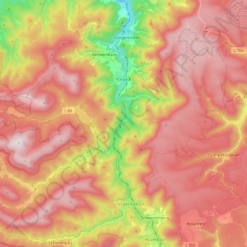
Name: Forbach topographic map, elevation, terrain.
Average elevation: 717 m
Minimum elevation: 201 m
Maximum elevation: 1,050 m
Make a donation
Gear up for your next adventure:
As an Amazon Associate, this site earns from qualifying purchases at no extra cost to you.
Other topographic maps
Click on a map to view its topography, its elevation and its terrain.
Schwarzenbachtalsperre
Deutschland > Baden-Württemberg > Landkreis Rastatt > Forbach
Der Stausee sammelt das Wasser am Ostabhang des niederschlagsreichen Hauptkamms des nördlichen Schwarzwalds, unterhalb von Hornisgrinde, Mehliskopf und Badener Höhe. Der Schwarzenbach und der Seebach werden direkt gestaut, das Wasser der Bäche Biberach und Hundsbach (Quellbäche der Raumünzach) wird per…
Average elevation: 699 m
Make a donation
Gear up for your next adventure:
As an Amazon Associate, this site earns from qualifying purchases at no extra cost to you.
Streitmannskopf
Deutschland > Baden-Württemberg > Landkreis Rastatt > Forbach
Average elevation: 776 m
Make a donation
Gear up for your next adventure:
As an Amazon Associate, this site earns from qualifying purchases at no extra cost to you.
Selbach
Deutschland > Baden-Württemberg > Landkreis Rastatt > Gaggenau > Selbach
Average elevation: 230 m
Make a donation
Gear up for your next adventure:
As an Amazon Associate, this site earns from qualifying purchases at no extra cost to you.
Make a donation
Gear up for your next adventure:
As an Amazon Associate, this site earns from qualifying purchases at no extra cost to you.
Sand
Deutschland > Baden-Württemberg > Landkreis Rastatt > Bühl
Der Sand ist eine zur Stadt Bühl gehörende Häusergruppe an der Schwarzwaldhochstraße (B 500) unterhalb des Mehliskopfes. Sie liegt im Nordschwarzwald auf einer Höhe von 824 m ü. NHN.
Average elevation: 805 m
Make a donation
Gear up for your next adventure:
As an Amazon Associate, this site earns from qualifying purchases at no extra cost to you.
Make a donation
Gear up for your next adventure:
As an Amazon Associate, this site earns from qualifying purchases at no extra cost to you.
Make a donation
Gear up for your next adventure:
As an Amazon Associate, this site earns from qualifying purchases at no extra cost to you.
Hundsbach-Aschenplatz
Deutschland > Baden-Württemberg > Landkreis Rastatt > Forbach
Average elevation: 835 m
Korbmatten Baden-Baden
Deutschland > Baden-Württemberg > Landkreis Rastatt > Baden-Baden > Steinbach
Average elevation: 136 m
Make a donation
Gear up for your next adventure:
As an Amazon Associate, this site earns from qualifying purchases at no extra cost to you.
Oberweier
Deutschland > Baden-Württemberg > Landkreis Rastatt > Bühl > Oberweier
Average elevation: 132 m
Talhof
Deutschland > Baden-Württemberg > Landkreis Rastatt > Gaggenau > Moosbronn
Average elevation: 452 m
Make a donation
Gear up for your next adventure:
As an Amazon Associate, this site earns from qualifying purchases at no extra cost to you.
Make a donation
Gear up for your next adventure:
As an Amazon Associate, this site earns from qualifying purchases at no extra cost to you.