Geolocate

Gurnee topographic map

Click on the map to display elevation.

About this map
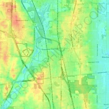
Name: Gurnee topographic map, elevation, terrain.

Location: Gurnee, Lake County, Illinois, United States (42.32744 -88.00264 42.40385 -87.88429)

Average elevation: 213 m

Minimum elevation: 195 m

Maximum elevation: 236 m

Other topographic maps

Click on a map to view its topography, its elevation and its terrain.
Third Lake

United States > Illinois > Lake County > Third Lake

Average elevation: 236 m

Gear up for your next adventure:

🧢Outdoor Visor - Breathable visor for sunny hikes
🧥Thermal Layer - Insulating layer for cold outdoor conditions
🧥Thermal Fleece Jacket - Versatile insulation for changing mountain temperatures
⛺Lightweight Backpacking Tent - Compact tent for efficient hiking trips
🧴Sunscreen SPF - Broad-spectrum sunscreen for outdoor activities

As an Amazon Associate, this site earns from qualifying purchases at no extra cost to you.