
Gurnee topographic map
Click on the map to display elevation.
About this map
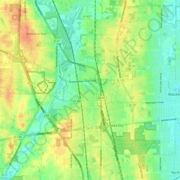
Name: Gurnee topographic map, elevation, terrain.
Location: Gurnee, Lake County, Illinois, United States (42.32744 -88.00264 42.40385 -87.88429)
Average elevation: 213 m
Minimum elevation: 195 m
Maximum elevation: 236 m
Other topographic maps
Click on a map to view its topography, its elevation and its terrain.
Waukegan
United States > Illinois > Lake County > Waukegan
Waukegan is located at 42°22′13″N 87°52′16″W / 42.37028°N 87.87111°W / 42.37028; -87.87111 (42.3703140, −87.8711404). Waukegan is on the shore of Lake Michigan, about 11 miles (18 km) south of the border with Wisconsin and 41 miles (66 km) north of downtown Chicago, at an elevation of…
Average elevation: 200 m