
Clabecq topographic map
Interactive map
Click on the map to display elevation.
About this map
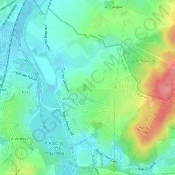
Name: Clabecq topographic map, elevation, terrain.
Location: Clabecq, Tubize, Nivelles, Brabant wallon, Wallonie, Belgique (50.67755 4.20841 50.70523 4.24654)
Average elevation: 58 m
Minimum elevation: 36 m
Maximum elevation: 111 m
Other topographic maps
Click on a map to view its topography, its elevation and its terrain.
Saintes
Belgique > Brabant wallon > Nivelles > Tubize
Saintes, Tubize, Nivelles, Brabant wallon, Wallonie, 1674, Belgique
Average elevation: 61 m
Le Stierbecq
Belgique > Brabant wallon > Nivelles > Tubize
Le Stierbecq, Tubize, Nivelles, Brabant wallon, Wallonie, Belgique
Average elevation: 55 m
Oisquercq
Belgique > Brabant wallon > Nivelles > Tubize
Oisquercq, Tubize, Nivelles, Brabant wallon, Wallonie, Belgique
Average elevation: 76 m