Geolocate

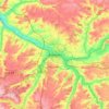
Croixrault topographic map

Click on the map to display elevation.

About this map

Name: Croixrault topographic map, elevation, terrain.

Location: Croixrault, Amiens, Somme, Hauts-de-France, Metropolitan France, 80290, France (49.77726 1.94999 49.81424 2.01922)

Average elevation: 164 m

Minimum elevation: 104 m

Maximum elevation: 192 m

Other topographic maps

Click on a map to view its topography, its elevation and its terrain.

Petit-Camon

France > Hauts-de-France > Somme > Camon

Average elevation: 73 m

Amiens

France > Hauts-de-France > Somme > Amiens

Average elevation: 86 m

Larronville

France > Hauts-de-France > Somme > Rue

Average elevation: 8 m

Gear up for your next adventure:

🧢Outdoor Visor - Breathable visor for sunny hikes
🥾Waterproof Trail Shoes - Shoes designed to handle wet terrain
🧥Thermal Layer - Insulating layer for cold outdoor conditions
🥾Hiking Gaiters - Protect legs and shoes from mud, snow, and debris
🧥Waterproof Hiking Jacket - Protect yourself from rain and wind while hiking

As an Amazon Associate, this site earns from qualifying purchases at no extra cost to you.