Geolocate

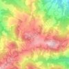
Fanano topographic map

Click on the map to display elevation.

About this map
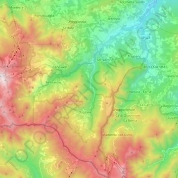
Name: Fanano topographic map, elevation, terrain.

Location: Fanano, Unione dei comuni del Frignano, Modena, Emilia-Romagna, 41021, Italy (44.11542 10.70123 44.25152 10.86225)

Average elevation: 1,080 m

Minimum elevation: 346 m

Maximum elevation: 2,152 m

Other topographic maps

Click on a map to view its topography, its elevation and its terrain.
Monte Cimone

Italy > Emilia-Romagna > Modena > Fiumalbo

The mountain has an elevation of 2,165 m and is also the highest point in the Emilia-Romagna region of Italy.

Average elevation: 1,759 m
Montombraro

Italy > Emilia-Romagna > Modena

Average elevation: 566 m

Monte della Torraccia

Italy > Emilia-Romagna > Modena > Montese

Average elevation: 923 m

Galleria

Italy > Emilia-Romagna > Modena > Campogalliano

Average elevation: 40 m

Barigazzo

Italy > Emilia-Romagna > Modena

Average elevation: 1,170 m

Pianorso

Italy > Emilia-Romagna > Modena

Average elevation: 846 m

Villanova

Italy > Emilia-Romagna > Modena > Modena

Average elevation: 32 m

Gear up for your next adventure:

🥾Waterproof Hiking Boots - Boots keeping your feet dry in wet conditions
🔪Outdoor Multitool - Versatile tool for repairs and food prep in the wild
🚲Heavy Duty Bike Lock - Secure your bike at the trailhead or during stops
🧭GPS Handheld Device - Reliable GPS navigation for outdoor adventures
🥾Durable Hiking Shoes - Long-lasting shoes for frequent hiking

As an Amazon Associate, this site earns from qualifying purchases at no extra cost to you.