Geolocate

Javier topographic map

Click on the map to display elevation.

About this map

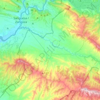
Name: Javier topographic map, elevation, terrain.

Location: Javier, Zangozerria, Navarre, 31411, Spain (42.42394 -1.34616 42.61304 -1.17548)

Average elevation: 623 m

Minimum elevation: 385 m

Maximum elevation: 1,148 m

Gear up for your next adventure:

🧶550 Survival Paracord - Versatile utility cord for emergency repairs and rigging
🥾Light Trekking Boots - Supportive boots for multi-day treks
🧤Insulated Winter Gloves - Heavy-duty protection for sub-zero Canadian adventures
🧢Sun Hat - Wide-brim hat for sun protection
🧢Hiking Sun Hat - Wide-brimmed protection for exposed mountain ridges

As an Amazon Associate, this site earns from qualifying purchases at no extra cost to you.