Geolocate

Lota topographic map

Click on the map to display elevation.

About this map

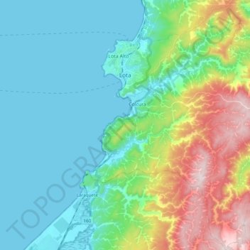
Name: Lota topographic map, elevation, terrain.

Location: Lota, Provincia de Concepción, Biobío Region, Chile (-37.20102 -73.18543 -37.04882 -73.04154)

Average elevation: 170 m

Minimum elevation: -1 m

Maximum elevation: 677 m

Gear up for your next adventure:

🧴Sunscreen SPF - Broad-spectrum sunscreen for outdoor activities
🥾Waterproof Hiking Boots - Boots keeping your feet dry in wet conditions
🛌Down Sleeping Bag - Superior warmth-to-weight ratio for cold nights
🥾Approach Shoes - Shoes designed for climbing approaches and rugged trails
🛰️Satellite Messenger - Emergency communication for areas with no cell service

As an Amazon Associate, this site earns from qualifying purchases at no extra cost to you.