
Thank you for supporting this site ❤️
Make a donation
Make a donation
Gear up for your next adventure:
As an Amazon Associate, this site earns from qualifying purchases at no extra cost to you.
Garoua-Boulaï topographic map
Click on the map to display elevation.
Thank you for supporting this site ❤️
Make a donation
Make a donation
Gear up for your next adventure:
As an Amazon Associate, this site earns from qualifying purchases at no extra cost to you.
About this map
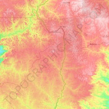
Name: Garoua-Boulaï topographic map, elevation, terrain.
Location: Garoua-Boulaï, Lom-et-Djérem, East, Cameroon (5.32941 14.19987 6.12910 14.62987)
Average elevation: 932 m
Minimum elevation: 701 m
Maximum elevation: 1,106 m
Thank you for supporting this site ❤️
Make a donation
Make a donation
Gear up for your next adventure:
As an Amazon Associate, this site earns from qualifying purchases at no extra cost to you.
Other topographic maps
Click on a map to view its topography, its elevation and its terrain.