
Carmen topographic map
Interactive map
Click on the map to display elevation.
About this map
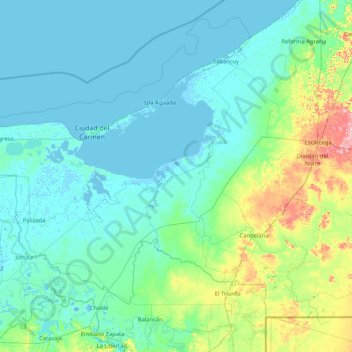
Name: Carmen topographic map, elevation, terrain.
Location: Carmen, Campeche, Mexique (17.87274 -92.46903 19.03233 -90.79543)
Average elevation: 20 m
Minimum elevation: -7 m
Maximum elevation: 174 m
Other topographic maps
Click on a map to view its topography, its elevation and its terrain.
FRACC. ISLA DEL CARMEN 2000
Mexique > Campeche > Carmen > Ciudad del Carmen > FRACC. ISLA DEL CARMEN 2000
FRACC. ISLA DEL CARMEN 2000, Ciudad del Carmen, Carmen, Campeche, 24100, Mexique
Average elevation: 2 m
Municipio de Campeche
Municipio de Campeche, Campeche, Mexique
Average elevation: 55 m